Tuesday, 17 July 2012

Reading the landscape

There is a wealth of content and material relating to landscape and sense of place on line, as categorised in the gazetteer of landscape on the web on this blog. And yet, to really get under the skin of the subject the physical book (or the ebook, if you are that way inclined) remains for me the best routeway into deeper understanding and contemplation; although building up a personal library does require both space and an understanding partner.

Click here for a selection of the books and journals that I feel provide a comprehensive and diverse landscape biblio-resource.

Saturday, 14 July 2012

A temporal space: channeling the Knights Templars, an exorcism and the Blitz


It may be due to the fact that I had just left the pub, but I think these images capture some of the mysterious, dare I say it, 'energy' that places with a long and eventful history seem to have; temporal layers interacting with spatial permanence.

This is Temple Church in central Bristol, now half-hidden in a somewhat bland and nondescript commercial district, its riverside location was one of the first areas of settlement during the city's earliest phase of development. Built in the late fourteenth century on the site of an earlier Knights Templar church it was bombed to its current shell in the Blitz of 1940, and was the scene of a famous eighteenth century exorcism.

Friday, 13 July 2012

Rural rides


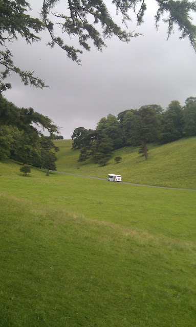
I don't know why this image particularly appeals to me, but it does. 

Taken today in the deer park of Dyrham Park, a National Trust property a few miles outside Bath, this is the shuttle bus that trundles all day up and down the hill from the car park to the main house.

What interests me is how this landscape of Arcadian perfection has been so thoroughly designed and redesigned over the last few centuries.

Originally a wooded combe cut into the southern-most extremity of the Cotswold scarp slope, this steep sided valley became part of the emparked hunting grounds of a medieval manor house. In an act of deliberate dislocation with the past the house was demolished in the late seventeenth century and replaced with a baroque mansion complete with ornate formal gardens, re-imagined in the fashionable Versailles style of the period and almost impossible to imagine on the site now (see image below). By the later eighteenth century the lavishly ornamental grounds had fallen out of style and were overlain with a 'naturalistic' designed park laid out by Humphrey Repton. This is largely the landscape that we can see today, possibly now fossilised into perpetuity by the National Trust, the stream issuing from the springs at the head of the valley long since buried underground.

And so back to our bus, following the course of medieval hunting parties and carriages transporting the Georgian and Victorian gentry through their contemporary visions of the ideal landscape, to be eventually replaced by who knows what.  

http://www.philaprintshop.com/images/kipdyrham.jpg
View of Dyrham Park by Johannes Kip (1712)

Wednesday, 4 July 2012

Sustainable transport v biodiversity and community food production: case study of a landscape dilemma

An interesting case currently bubbling up on my doorstep in East Bristol that highlights the difficulties created when competing demands, each with their own merits, are placed on the landscape.

For a city that prides itself on being progressively 'green', Bristol has been slow off the mark in addressing car dependency and the city council is seeking to address this with its Bus Rapid Transit Scheme, a major infrastructure project in partnership with adjoining local authorities to connect employment and transport hubs with residential districts via upgraded or new dedicated bus routes. The scheme includes a proposed new 'bus-only' junction at Stapleton giving access to the M32 motorway into the city centre. The council has put the plans out to consultation with a formal planning application later in the year.

This is a worthy and progressive scheme to try and put Bristol's transport infrastructure on a more sustainable footing. The problem is that the site adjacent to the motorway earmarked for the development is part of a 'green finger' of open land that extends well into the urban suburbs of the city. Under threat is a belt of overgrown but well-loved fields and old market-garden allotments, mostly held by local tenants; grade 1 agricultural land under-utilised in recent times but of high value in terms of potential productivity, biodiversity, habitat and the aesthetics of urban open space. Furthermore, the lands premature early retirement into ragged nature has been partially halted by a Lottery-funded Avon Wildlife Trust initiative called Feed Bristol, which has recently seen 7 acres at the heart of the area in question given over to a community food growing project. Many people, myself included, are now advocating that such traditionally overlooked and neglected edgelands should be utilised much more for crop and livestock production through community schemes like this with the multiple social and environmental advantages that accrue, rather than facing incremental loss at the hands of commercial development with often dubious local benefit.

And there is the rub. If this was a rapacious multi-national predator threatening green space then how much more straight-forward the case for opposition would be to construct, albeit not necessarily more likely to succeed. However, if you are concerned with environmental impact both locally and more widely (and there are many who do not see this as a concern, whether due to apathy or the perceived automatic primacy of 'the economy'), where does your support lie in a case like this? In defence of the local green space or the, perhaps, wider social good of the rapid transport scheme?